





Google Cloud Tools Help U.S. Forest Department Generate Years of Insights into Earth’s Natural Resources

5016
Of your peers have already read this article.
3:00 Minutes
The most insightful time you'll spend today!
For 117 years, the U.S. Department of Agriculture’s Forest Service has been a steward of America’s forests, grasslands, and waterways. It directly manages 193 million acres and supports sustainable management on a total of 500 million acres of private, state, and tribal lands. Its impact reaches far beyond even that, offering its research and learning freely to the world.
At Google, we’re big admirers of the Forest Service’s mission. So we were thrilled to learn in 2011 that its scientists were using Google Earth Engine, our planetary-scale platform for Earth Science data and analysis, to aid its research, understanding, and effectiveness. In the years since, Google has worked with the Forest Service to meet its unique requirements for visual information about the planet. Using both historical and current data, the Forest Service built new products, workflows, and tools that help more effectively and sustainably manage our natural resources. The Forest Service also uses Earth Engine and Google Cloud to study the effects of climate change, forest fires, insects and disease, helping them create new insights and strategies.
Besides gaining newfound depths of insight, the Forest Service has also sped up its research dramatically, enabling everyone to do more. Using Google Cloud and Earth Engine, the Forest Service reduced the time it took to analyze 10 years worth of land-cover changes from three months to just one hour, using just 100 lines of code. The agency built new models for coping with change, then mapped these changes over time, in its Landscape Change Monitoring System (LCMS) project.
Emergency responders can now work better on new threats that arise after wildfires, hurricanes, and other natural disasters. Forest health specialists can detect and monitor the impacts of invasive insects, diseases, and drought. More Forest Service personnel can use new tools and products within Earth Engine, thanks to numerous training and outreach sessions within the Forest Service.
Researchers elsewhere also benefited when the Forest Service created new toolkits, and posted them to GitHub for public use. For example, there’s geeViz, a repository of Google Earth Engine Python code modules useful for general data processing, analysis, and visualization.
This is only the start. Recently, the Forest Service started using Google Cloud’s processing and analysis tools for projects like California’s Wildfire and Forest Resilience Action Plan. Forest Service researchers also use Google Cloud to better understand ecological conditions across landscapes in projects like Fuelcast, which provides actionable intelligence for rangeland managers, fire specialists, and growers, and the Scenario Investment Planning Platform for modeling local and national land management scenarios.
The Forest Service is a pioneer in building technology to help us better understand and care for our planet. With more frequent imaging, rich satellite data sets, and sophisticated database and computation systems, we can view and model the Earth as a large-scale dynamic system.
We are honored and excited to respond to the unique set of requirements of the scientists, engineers, rangers, and firefighters of the USFS, and look forward to years of learning about — and better caring for — our most precious resources.
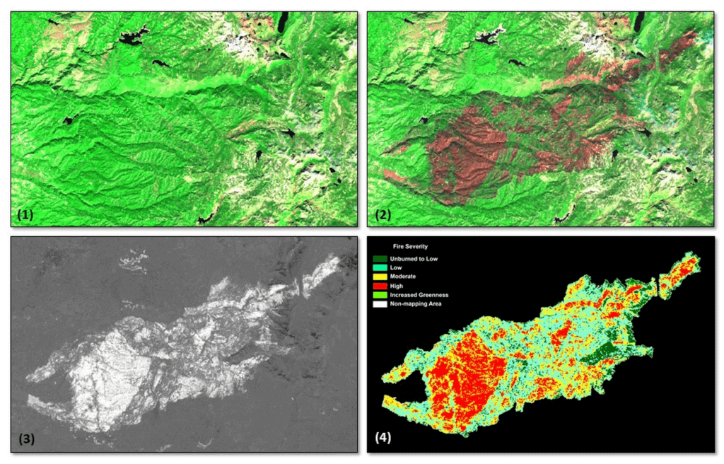
*Image 1: The USDA Forest Service (USFS) Geospatial Technology and Applications Center (GTAC) uses science-based remote sensing methods to characterize vegetation and soil condition after wildland fire events. The results are used to facilitate emergency assessments to support hazard mitigation, to inform post-fire restoration planning, and to support the monitoring of national fire policy effectiveness. GTAC currently conducts these mapping efforts using long-established geospatial workflows. However, GTAC has adapted its post-fire mapping and assessment workflows to work within Google Earth Engine (GEE) to accommodate the needs of other users in the USFS. The spatially and temporally comprehensive coverage of moderate resolution multispectral data sources (e.g., Landsat, Sentinel 2) and analytical power provided by GEE allows users to create geospatial burn severity products quickly and easily. Box 1 shows a pre-fire Sentinel-2 false color composite image. Box 2 shows a post-fire Sentinel-2 false color composite image with the fire scar apparent in reddish brown. Box 3 shows a differenced Normalized Burn Ratio (dNBR) image showing the change between the pre- and post-fire images in Boxes 1 and 2. Box 4 shows a thresholded dNBR image of the burned area with four classes of burn severity (unburned to high severity), which is the final output delivered to forest managers.
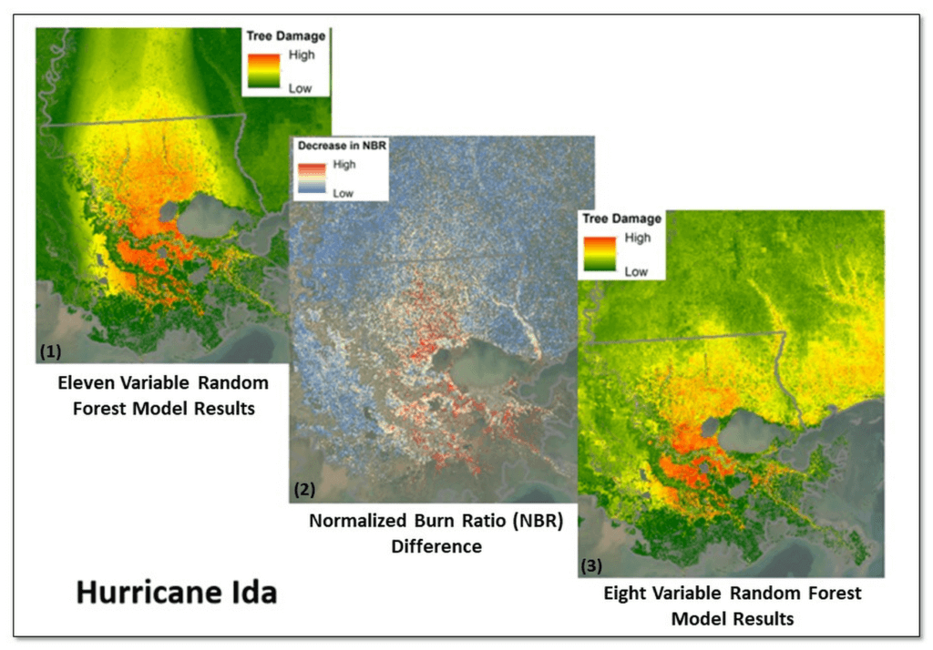
*Image 2: Leveraging Google Earth Engine (GEE), the USDA Forest Service (USFS) Geospatial Technology and Applications Center (GTAC) and USFS Region 8, developed the Tree Structure Damage Impact Predictive (TreeS-DIP) modeling approach to predict wind damage to trees resulting from large hurricane events and produce spatial products across the landscape. TreeS-DIP results become available within 48 hours following landfall of a large storm event to allow allocation of ground resources to the field for strategic planning and management. Boxes 1 and 3 above show TreeS-DIP modeled outputs with varying data inputs and parameters. Box 2 shows changes in greenness (Normalized Burn Ratio; NBR) that was measured with GEE during the recovery from Hurricane Ida and is shown as a visual comparison to the rapidly available products from TreeS-DIP.
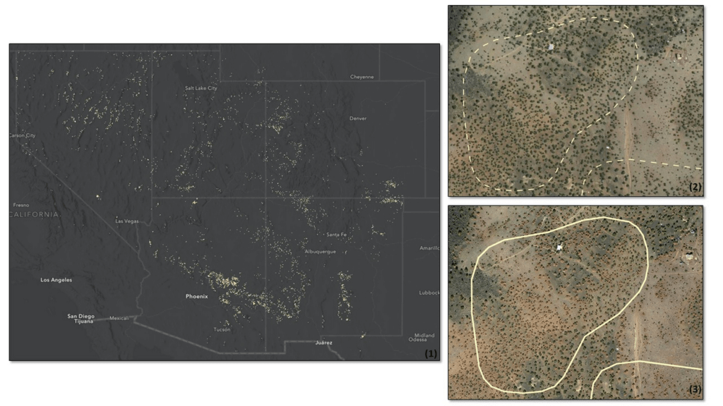
*Image 3: Severe drought conditions across the American West prompted concern about the health and status of pinyon-juniper woodlands, a vast and unique ecosystem. In a cooperative project between the USDA Forest Service (USFS) Geospatial Technology and Applications Center (GTAC) and Forest Health Protection (FHP), Google Earth Engine (GEE) was used to map pinyon pine and juniper mortality across 10 Western US States. The outputs are now being used to plan for future work including on-the-ground efforts, high-resolution imagery acquisitions, aerial surveys, in-depth mortality modeling, and planning for 2022 field season work.
Box 1 contains remote sensing change detection outputs (in white) generated with GEE, showing pinyon-juniper decline across the Southwestern US. Box 2 shows NAIP imagery from 2017 with, with box 3 showing NAIP imagery from 2021. NAIP imagery from these years shows trees changing from healthy and green in 2017 to brown and dying in 2021. In addition, box 2 and box 3 show change detection outputs from Box 1 for a location outside of Flagstaff, AZ converted to polygons (in white). The polygon in box 2 is displayed as a dashed line to serve as a reference, while the solid line in box 3 shows the measured change in 2021. Converting rasters to polygons allows the data to be easily used on tablet computers, as well as the ability to add information and photographs from field visits.
How the City of Memphis Uses Technology to Identify 75 Percent More Potholes

7136
Of your peers have already read this article.
4:30 Minutes
The most insightful time you'll spend today!
At 340 square miles, the City of Memphis is among the largest in the United States in terms of land area. Memphis has over 6,800 lane-miles of city streets, enough to drive back and forth to Los Angeles four times. Keeping these streets well maintained and safe for citizens and visitors is a major priority for the city.
Lots of traffic, lots of roads, and a four-season climate prone to wintertime freeze-thaw-refreeze cycles means the opportunity for potholes. Although the city aims to fill potholes within five business days of notification, it can take longer, especially during winter and early spring. Last year, the city’s Public Works crews repaired some 63,000 potholes, only 20% of which were reported by residents. Approximately 32,000-man-hours each year are spent repairing potholes, with seasonal fluctuations requiring ten to twelve Street Maintenance crews working steadily during the winter months. Still, many went unreported, leading the city to flag pothole request resolution under “needs improvement” on its open data portal website.
Like many large cities, Memphis also struggles with vacant and blighted properties. Nearly 15,000 properties in Memphis are likely vacant, and city officials contend that many are owned by out-of-town investors who live elsewhere and do not take necessary restoration or maintenance steps. These properties can decrease the value of surrounding real estate and discourage new businesses and other residents from moving to an area. Citizen frustration and concerns over the number of blighted properties has made blight eradication a major focus of the City of Memphis.
Historically, residents reported potholes and blighted properties by calling 311, or more recently by using the Memphis 311 app. However, these reports only covered about 20 percent of the problems — often the worst cases. And by the time residents took the initiative to submit a 311 report, they usually weren’t feeling good about the situation.
Recognizing that potholes and vacant properties are often the most visible indicators of whether a city government is doing its job efficiently, Memphis Mayor Jim Strickland and CIO Mike Rodriguez began looking for ways they could apply technology to fix the problems. Mike approached Google for ideas, and Google recommended conducting a machine learning proof-of-concept (POC) with SpringML, a Google Cloud Partner.
“Memphis is focused on easy living, and we want to do everything we can to keep our citizens happy,” says Mike Rodriguez. “Working with Google and SpringML to reduce potholes and urban blight using machine learning and artificial intelligence was an easy decision.”
Bringing machine learning to city operations and budgets
The city’s goal is to detect potholes and abandoned properties by analyzing video footage of roads and residential properties. It wanted to classify potholes by width and depth, and share the information with workers who can repair them. For abandoned properties, it wanted to enable more strategic deployment of resources for homeowners citywide and take action to hold neglectful property owners accountable.
The POC began by training TensorFlow models for ML object detection using preconfigured AI Platform Deep Learning VM Images on Compute Engine. SpringML helped set up cameras and developed a user interface to collect pothole data and automate the 311 ticketing process.
Together, the teams analyzed 30 days of video from a moving city bus and high-resolution video from 360-degree cameras mounted to a code enforcement vehicle, overlaid with data from 311 reports. As the models were refined, accuracy quickly climbed from 50 percent to over 90 percent as models were taught to differentiate a pothole from a manhole cover or other object.
The city also imported routes, potholes, and paving data along with geolocation data from ArcGIS and Google Maps into BigQuery to better understand street conditions and the proximity of potholes to one another. BigQuery also analyzes city property records, tax records, 311 reports, and third-party survey data on-demand to predict where homes are starting to become run down and where neighborhood decay is most likely to occur. The SpringML team created a pilot analysis to begin vacant property protections and developed a user interface tool to interact with the model’s results.
“Google Cloud Platform made it possible for us to experiment with machine learning and artificial intelligence to help solve our city’s problems while working within the budget constraints of a municipal IT organization,” says Mike. “Google turned a ‘nice to have’ into a ‘let’s do this!'”
Identifying 75 percent more potholes
Memphis expects to substantially reduce the number of potholes on its streets, creating a better driving experience for residents and visitors alike. Because drivers won’t be as likely to swerve to miss a pothole, streets will be safer and friendlier to bicycles and scooters. Fewer potholes will also save the city between $10,000 and $20,000 annually in city claims that it pays out in cases where vehicle damage results from a pothole that was not addressed in a timely manner.
“Historically, Public Works has relied primarily upon Street Maintenance crews to proactively locate and fill potholes. As Memphis has over 6,800 lane-miles of public streets, it is a daunting task to reliably survey the entire system in an efficient and systematic way,” says Robert Knecht, Public Works Director for the City of Memphis. “The outcome of the data collected will be invaluable to Public Works so that it can ensure it is managing the city’s street system in a more proactive manner.”
Memphis will be able to better prioritize road maintenance based on condition and impact, increasing the efficiency of its Public Works road crews. Analyzing video of streets also gave the city visibility into issues it wasn’t previously aware of, such as curbs, gutters, and manhole covers that had been mistakenly paved over and need to be excavated. The ML process is easily transferrable to other concerns as well, helping the city identify illegal signs or spools of cable hanging on light posts that could be potentially unsafe.
Helping communities recover and thrive
Memphis is also having success in analyzing predictive trends to combat high rates of abandoned and blighted properties, surpassing 97.5 percent accuracy. “In the past, Public Works experimented with comprehensive, city-wide blight identification by using approximately 200 volunteers to survey and photograph over 237,000 city parcels. This effort was costly, took a long time to complete, and resulted in inconsistent data collection,” says Robert. “Blighted property conditions can change quickly in a city the size of Memphis. Now, with this new technology, Memphis will be able to make a significant difference in the efforts to proactively and comprehensively identify and manage blighted and substandard properties.”
Code Enforcement with better data-driven detection mechanisms enables the city to also identify cases where homeowners are not physically or financially able to keep up with the challenges of homeownership and make them aware of resources that are available to assist them. Memphis Code Enforcement can do a better job of finding people living in derelict properties that pose hazards to inhabitants’ health and safety, and help them fix those problems or find a new place to live.
“Using SpringML and Google Cloud Platform to detect indicators of vacant or blighted properties will help Memphis create safer neighborhoods that will be more attractive to businesses and home buyers,” says Mike. “Property values and employment will go up, crime will go down, and social services can be more focused and effective.”
Revolutionizing service delivery for citizens
Memphis is proving the viability of a cost-effective, cloud-based machine learning model that other cities can follow. The city is already looking into new applications of AI and ML that will further improve city services and help it build a better future for its 652,000 residents.
As part of his commitment to a transparent government, Memphis Mayor Jim Strickland created an open data policy that commits to releasing raw data and sharing it with citizens in a variety of downloadable formats. Going forward, this transparency will help citizens understand how their needs are being served and uncover new, innovative use cases for AI and ML.
“Our goal is to become a smart city, and technologies such as Google Cloud Platform and SpringML put us ahead of the game,” says Mayor Strickland. “Google understands data, and there isn’t a better company to help us analyze our data resources for actionable insights.”
4904
Of your peers have already watched this video.
9:37 Minutes
The most insightful time you'll spend today!
L’Oréal: Managing Big-data Complexity with Google Cloud
L’Oreal is a global company with a presence in 150 countries worldwide. Between managing all of its brands and requirements for different countries, L’Oreal looks to data to make insightful business decisions. How does L’Oreal unify its data across all its systems and databases? How does L’Oreal make the data accessible to thousands of employees? In this video, Antoine Castex, Enterprise Architect at L’Oreal, discusses with Martin Omander how L’Oreal built a serverless, multi-cloud warehouse based on Google Cloud.
Chapters:
0:00 – Intro
0:23 – Why does L’Oreal need a new data warehouse?
0:51 – Who is the L’Oreal group?
1:35 – Which systems does L’Oreal use?
2:14 – How does L’Oreal manage complexity?
3:59 – What is ELT?
4:57 – Who are L’Oreal’s data consumers?
5:41 – How L’Oreal built the data warehouse
8:51 – L’Oreal’s future plans
9:10 – Wrap up
Google Cloud Workflows → https://goo.gle/3q20M1V
Cloud Run → https://goo.gle/3CSWbXG
Eventarc → https://goo.gle/3B7qhFy
BigQuery → https://goo.gle/3KHgyJ3
Looker → https://goo.gle/3Rx4Ind
Checkout more episodes of Serverless Expeditions → https://goo.gle/ServerlessExpeditions
Subscribe to Google Cloud Tech → https://goo.gle/GoogleCloudTech
3793
Of your peers have already watched this video.
8:00 Minutes
The most insightful time you'll spend today!
Target Leverages Google Cloud to Create Market-defining Online Experience
In the hyper-competitive world of online retail sales, ease-of-use and transaction speed can make or break business outcomes. However, a few years ago US Retail giant Target was going through a period of uncertainty.
While the company had over 1800 stores across the US with an estimated 85% of US consumers shopping at a Target store and over 25 million people visiting the Target website or using its app each month, it was still losing ground.
In spite of having millions of loyal customers, the company was dangerously late on digital and its technology wasn’t keeping pace with unstable systems to boot. The company faced the twin challenges of trying to operate today’s business as efficiently as possible and creating tomorrow’s business as quickly as possible. On the one hand it needed productivity and stability and on the other it wanted speed and disruption. Not an easy task to accomplish.
That’s when Target decided to use Google Cloud to solve its challenges. See how Target leveraged Google Cloud to create a market-defining online experience that has made customers happier and more loyal.
4583
Of your peers have already watched this video.
1:30 Minutes
The most insightful time you'll spend today!
Introduction to Cloud Shell Editor
Watch the video to understand how Google’s Cloud Shell Editor and its powerful features-packed environment can streamline your development workflows.
How OnlineSales.ai and Google Cloud Helped TATA 1mg Increase Ad Revenue by 700%

1375
Of your peers have already read this article.
3:30 Minutes
The most insightful time you'll spend today!
Editor’s note: We invited partners from across our retail ecosystem to share stories, best practices, and tips and tricks on how they are helping retailers transform during a time that continues to see tremendous change. This original blog post was published by OnlineSales.ai. Please enjoy this updated entry from our partner.

Tata’s online healthcare entity, Tata 1mg, aims to revolutionize how a consumer finds the right healthcare professional for their needs. The platform offers e-pharmacy services, diagnostics, and health content and has more than 200,000 active brands in its rapidly expanding list of suppliers, sellers and manufacturers. Several of these brands would need regular involvement from the marketplace team in order to set up and run ad campaigns. As one of the largest platforms, Tata 1mg approached OnlineSales.ai to address their growing needs for an efficient Retail Media Monetisation suite to help scale up their existing monetisation efforts.
Tata 1mg needed more data-driven insights and customizability for their monetisation efforts
Tata 1mg saw several challenges that they needed to address.
- Manual effort: Tata 1mg marketplace team’s monetization process was largely manual and required heavy time and resource investment to activate advertisers, which subsequently ate into their overall ad revenues.
- Non-scalable framework: Given the fast-growing number of advertisers on their marketplace – well into the hundreds of thousands – it became increasingly clear that their existing monetization framework was not scalable.
- Inadequate reporting & analytics: The existing framework facilitated only simple reporting, and brands were not able to draw the deep insights they needed to make data-led decisions and refine their advertising ROIs.
- Steep learning curve: Several brands lacked dedicated advertising experts who could bring the experience and skills needed to plan successful ad campaigns and optimize budgets. The involved learning curve led to increased advertiser-churn.
- Lack of personalized offerings: The manual nature of Tata 1mg’s monetization framework left little room for customizability, and account managers could offer very little in terms of tailored ad-buying experiences to different types of advertisers.
All of these issues led to regular revenue leakage. Tata 1mg realized the need for a central platform that addressed the above-mentioned issues and would also be able to cater to new ad channels and the requirements thereof. Developing such a solution in house was evaluated, but was found to be expensive and would require a lot of time to build.
OnlineSales.ai’s AI/ML-powered solution on Google Cloud offered the automation and flexibility to support modern omnichannel advertising needs
Therefore, Tata 1mg looked to OnlineSales.ai Monetize, an AI/ML-powered retail media monetisation suite on Google Cloud, to help address their needs for a cloud-based monetisation platform that offered the flexibility to support omnichannel advertising models, had automation built in to reduce manual tasks, provided detailed intelligence and analytics, and delivered quick, reliable scalability.
- White labeled self-serve platform: OnlineSales.ai’s retail media platform was implemented within a short 4 weeks. After thorough testing and implementation, the platform was successfully launched, and enabled sellers to run ads on a fully self-serve platform. This required zero involvement from the Tata team.
- Unified omni channel buying: The team at OnlineSales.ai worked closely with the platform’s core teams to activate and mobilize various advertising products through a self-serve platform, while simultaneously addressing any unique requirements they had.
- Omnichannel analytics with AI-led suggestions: Sellers are now also able to generate detailed reports that provide them critical insights into campaigns, and help them make better use of their budgets – enhancing their experience and interest in advertising on the platform.
- Personalized buying experiences: The tailored UX offered by OnlineSales.ai’s Monetize helped Tata engage brands of all levels in technical aptitude to use the platform easily. This also allowed admins to configure what types of inventories were available to different brands or advertiser segments.
OnlineSales.ai makes use of Google Cloud Dataflow to facilitate computations on real-time streaming. Microservices are deployed on the Google Kubernetes Engine (GKE) platform due to the solution’s well-known ability to handle scale.
In addition, Dataproc is used by the company to run batch processing apps while Cloud Load Balancing helps manage traffic across different regions; all at scale. Onlinesales.ai also uses Memorystore as a database for their ad servers in order to have very low latency, and deploys BigQuery to run analytical applications and facilitate powerful reporting. The bulk of their office applications are deployed on different VMs on Compute Engine, and the company also makes use of Cloud Storage for data storage and transfers between applications.
Learn more about OnlineSales.ai available on the Google Cloud Marketplace.
About OnlineSales.ai
OnlineSales.ai, offers a fully white labeled retail media platform which helps retailers unlock additional revenue by activating advertising real estate on their platform. With its AI/ML-powered solution, OnlineSales.ai allows retailers to turn brands of all sizes into advertisers – at scale. Its self-serve platform simplifies the ad buying process, and enhances outcomes with smart automation, boosting ad retailers’ ad revenues by multiples.
More Relevant Stories for Your Company

Data Cloud Skills to Pick Up in 2022: Google Experts Recommended
It’s 2022 and nanosatellites, NFTs, and autonomous cars that deliver your pizza are in full force. In a world where people rely on simple technology to untangle complex problems, companies must deliver simple experiences to be successful in today’s landscape. For many cloud providers this means enabling tightly integrated data

Google Cloud Helps LiveRamp Capture, Manage, Process and Visualize Data at Scale
Editor’s note: Today we’re hearing from Sagar Batchu, Director of Engineering at LiveRamp. He shares how Google Cloud helped LiveRamp modernize its data analytics infrastructure to simplify its operations, lower support and infrastructure costs and enable its customers to connect, control, and activate customer data safely and securely. LiveRamp is a data

How BigQuery’s Unique Features Support Your Data at Petabyte-scale
Organizations rely on data warehouses to aggregate data from disparate sources, process it, and make it available for data analysis in support of strategic decision-making. BigQuery is the Google Cloud enterprise data warehouse designed to help organizations to run large scale analytics with ease and quickly unlock actionable insights. You

Google’s Intelligent Products Essentials Assist Manufacturers in Product Development Journey
Expectations for both consumer and commercial products have changed. Consumers want products that evolve with their needs, adapt to their preferences, and stay up-to-date over time. Manufacturers, in turn, need to create products that provide engaging customer experiences not only to better compete in the marketplace, but also to provide
